UNITED STATES OF AMERICA
FEDERAL ENERGY
REGULATORY COMMISSION
COMMENT
DOCKET #
P-2197-060
APPLICANT: Alcoa
Power Generating Inc.
Name of Project:
Yadkin
As stated in our previous filings on Feb. 19, 2003 (Ferris
submittal 20030228-0063) and
subsequently on Feb. 26, 2003 (Ferris submittal 20030226-5042), we are
requesting that Alcoa Power Generating Inc.’s Yadkin Drought Contingency Plan
for 2003 be rejected as inadequate and incomplete.
The directive from the FERC stated the plan should examine alternative
management practices, early reduction in discharges and describe an
implementation schedule. It also
stated that one of the principle goals of the plan should be to ensure that the
elevation of
High
Rock
Lake
is maintained within five feet of full pool.
Finally, the directive offered the assistance of the FERC staff to assist
in the development of the plan.
The Plan submitted by APGI actually contains no steps to
address the items specifically mentioned in the directive from the FERC and
contains no specific implementation schedule.
More importantly, the creators of the Plan specifically chose to ignore
the input of the NCDENR after recognizing them as being “experts” in natural
resource management and protection. Finally,
after stating in the footnotes that they did not understand why they were being
asked to create such a plan, there is no evidence of any request for assistance
from the FERC staff as had been offered.
The events of 2001 and 2002 proved beyond any reasonable
doubt that the “rule curve” and drawdown schedules included in the current
license are inadequate to properly protect this valuable natural resource.
The current “rule curve” appears to contain conflicting goals of
maintaining reservoir levels and discharge levels without clear guidance as to
which should take priority if both conditions can not be maintained.
The current terminology states that the discharge from Project 2197
should be “limited to” specific figures based on the time of the year but
does not distinguish if this is a minimum limit or a maximum limit.
APGI interprets this to be a minimum discharge which is in direct
conflict with the elevation limits if inflow is not considered.
In most situations where a “limit” is imposed, such as a “speed
limit”, it is a maximum limit. Management
of the river basin during low flow conditions must include all of the reservoirs
to adequately protect the interests of all stakeholders.
We have survived what we all hope will be the worst case
scenario for the Yadkin-Pee Dee river basin and have the actual measured stream
flow data available to use for modeling future operational scenarios.
In the absence of a detailed Drought Contingency Plan designed to protect
the interests of all of the stakeholders in the Yadkin-Pee Dee River basin
during periods of drought and/or low flow conditions, we respectfully request
that ALL of FERC Project 2197 and FERC Project 2206 be directed to operate as
“run of the river” facilities.
We realize that a simple “run of the river” operation
for both projects would be easiest regime to implement and should cover the
basic environmental considerations downstream.
Riparian areas downstream have no reasonable right to expect any more
water to be discharged from the projects than comes into them at any time.
As an organization concerned about the welfare of the whole river basin,
we feel that when evaluating the benefit of the projects to the public,
reasonable consideration of downstream areas should be included during periods
of drought. LIMITED consumption of
the storage capabilities of the reservoirs should be considered during periods
of prolonged or extreme drought but only within boundaries that will ensure the
protection of the reservoirs themselves and the communities surrounding them.
At this time we appear to be the only organization who has
taken the time to do any analysis of the actual flow data recorded by the USGS
sensors around the two Projects during this period of extreme drought.
We developed a spreadsheet model using the actual flow readings from the
Yadkin
College
and
Rocky River
sensors for 2001 and 2002. We
tested several different management scenarios to evaluate the effects of
different discharge limits on total storage capacity at
High
Rock
Lake
. The calculations in the
spreadsheet assumed the following, based on the concept of being in extreme
drought conditions:
- The
total capacity of
High
Rock
Lake
is 230,000 Acre Feet. All
results are calculated based on the remaining acre foot capacity in
High
Rock
Lake
.
- The
primary goal is to maintain each lake as close as possible to full pool and
to maintain a “minimum discharge target” of 1200 cfs at the Rockingham
NC USGS sensor.
- Twenty
percent of the flow at the Rockingham NC USGS sensor is contributed by
sources other than what is measured at the Yadkin College USGS sensor.
- Changes
to Inflow readings at the Yadkin College USGS sensor, the Rocky River USGS
sensor and the calculated Twenty percent are reacted to on a daily basis.
- No
more water than is absolutely necessary is discharged from Project 2197 to
maintain the “minimum discharge target” at the Rockingham NC. USGS
sensor
- The
“
Target
Range
” for
High
Rock
Lake
is between 180,000 Acre Feet and 230,000 Acre Feet (within 4 feet of full
pool)
- The
primary goal for refill is to return all lakes to their “
Target
Range
” before increasing the discharge at the Rockingham USGS sensor to full
“run of the river” flow.
We understand that the very rigid process of daily reaction
to river flow conditions would be difficult to duplicate in the real world but
the concept is used to allow for trend analysis and comparisons to the exact
same concept using higher minimum discharge readings at the Rockingham NC USGS
sensor. Since the discharge
adjustments for different times of the year included in the present license are
not included in the calculations, the current discharge limit figures were
averaged together and the simulation was run using the average of 1626 cfs.
Below is a graph of the results.
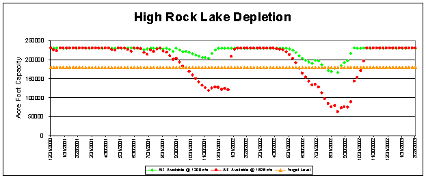
The results clearly indicate that proper prioritization and
management of the watershed during extreme drought conditions with quick
reaction to decreasing river flow conditions and a realistic minimum discharge
figure at the Rockingham NC USGS sensor would have resulted in a greatly reduced
impact to the entire river basin. For
the sake of simplicity, this graph only indicates the potential acre foot
depletion at
High
Rock
Lake
and assumes that every other lake was maintained at or near full pool.
Including the proportional drawdowns in our proposal, it is possible that
no lake would have been drawn down more than 4 or 6 feet during 2002 and the
discharge into the
Pee Dee
River
would have been maintained at a 25 percent higher level.
We would like to propose the following Operating Guidelines
for Project 2197 and Project 2206 for consideration.
- Establish
a “
Target
Range
” of full pool to -4 feet for High Rock, Badin, Falls, Tillery and
Blewett
Falls
Lakes
and full pool to -3 feet for Tuckertown.
- Establish
a “Target Level” at
High
Rock
Lake
of 2 to 3 feet below full pool.
- Establish
a maximum drawdown of 8 feet below full pool for High Rock, 3 feet below
full pool for Tuckertown, 12 feet below full pool for Badin, Falls and
Tillery and 6 feet below full pool for
Blewett
Falls
Lake
.
- Establish
a “minimum discharge target” at the Rockingham NC USGS sensor of 1200
cfs.
- Operate
all of project 2197 and project 2206 as “run of the river”.
Any time inflow to
High
Rock
Lake
drops below the “minimum discharge target”, attempt to hold each lake
within it’s target range by discharging no more from project 2197 than is
necessary to maintain the “minimum discharge target” at the Rockingham
NC USGS sensor.
- Once
High
Rock
Lake
is 4 feet below full pool, begin a 3 foot drawdown at Tuckertown then a 4
foot drawdown at
Badin
Lake
,
Falls
Lake
,
Lake
Tillery
and finally
Blewett
Falls
Lake
.
- Once
every lake is 4 feet below full pool, have a group of stakeholders (state
agencies and representatives from other stakeholder groups) determine a new
value for the “minimum discharge target” at the Rockingham NC USGS
sensor. Reduce the Blewett Falls
discharge as measured at the Rockingham NC USGS sensor to that value and
begin an additional 2 foot drawdown at each lake beginning with Blewett
Falls Lake and working progressively back up the chain toward High Rock
Lake.
- Continue
this down the chain, up the chain process until each lake has reached its
maximum allowable drawdown. On
each successive 2 foot drawdown pass have the stakeholder group establish a
reduced value for the “minimum discharge target” and use this value for
the target at the Rockingham NC USGS sensor.
If every lake has reached its maximum drawdown, discharge no more
from any of the lakes than is flowing into that lake (true run of the
river).
- Once
stream inflow to
High
Rock
Lake
rises above the “minimum discharge target” refill all reservoirs
proportionally until each has reached its target level of within 4 feet of
full pool before returning the discharge from the
Blewett
Falls
dam to full “run of the river” levels.
Actual modeling of the above scenario using a watershed
modeling program like OASIS and the measured flow figures from 2001 and 2002
would provide more accurate information concerning the impact to each reservoir
and the flows in the
Pee Dee
River
during that period. If modeling of
this scenario truly supports the conclusions derived from our spreadsheet model,
we respectfully request that these rules be adopted and used until the
relicensing of both Projects is completed.
We feel that these guidelines give appropriate consideration to all of the
stakeholders interests. Under normal
conditions, on a weekly basis almost all of the water coming into project 2197
and project 2206 would be used for hydropower generation and discharged into the
Pee Dee
River
. This would more closely
approximate the conditions of an unencumbered river system and provide for more
natural seasonal fluctuations. If
High
Rock
Lake
is maintained at a target level of about
-2 to -3
feet, there would be a modest level of storage capacity (30,000 to 35,000 acre
feet) there to allow for short term regulation of downstream flows. The
4 foot “target range” at each lake would provide a total of approximately
120,000 acre feet of storage capacity in the river basin that would be available
without needing to make variance requests. Drawdowns
beyond this level would be pre-approved under the guidance of the recognized
natural resource management experts with appropriate limits necessary to protect
the environment, municipal water supplies and the rights of other defined
stakeholders. This should maintain
the shortest retention period for the water in each lake and hopefully
contribute toward better water quality and provide the highest quality
environment for the fish and wildlife. It
should maintain all lakes at a level that is acceptable for safe recreational
use. Reaction to stream flows as low
as 1200 cfs would become part of weekly power generation scheduling and should
minimize the impact to the reservoirs and flows in the
Pee Dee
River
. Delays introduced by inadequate or
unclear regulations requiring variance requests would be eliminated.
The life of the stored reserves during periods of extended or extreme
drought would be maximized and the time needed to replenish those reserves
should be minimized. We feel that
this is an operational model that contains clear and concise goals and limits.
When flow conditions are extremely low for extended periods of time,
those most knowledgeable in natural resource management and protection would be
empowered to make the appropriate “judgment call” decisions.
In conclusion, we feel that it meets all of the requirements of the
directive issued by the FERC to APGI on
December 20, 2002
.
The key to successful drought management is the establishment of
reasonable minimum and maximum flow and reservoir elevation limits as well as
the REQUIREMENT to react quickly to changing stream flow conditions.
Respectfully submitted,
Robert W. Petree
Chairman of the
Board
SaveHighRockLake.org